Eagle Viewing Area / Siyich'em Reserve Dike Master Plan

Introduction
The District of Squamish completed an Integrated Flood Hazard Management Plan (IFHMP) in 2017 that included over 100 recommendations to manage community flood risk. The IFHMP identified significant deficiencies in the Squamish River dike at the Eagle Viewing Area and Siyich’em Reserve along with unique challenges to complete upgrades including multiple land owners, major infrastructure within and adjacent to the dike and environmental sensitivity. As a result, the IFHMP recommended completing a special study to determine an approach to upgrading the Squamish River dike through this area.
In 2019/2020, the District of Squamish and Squamish Nation developed an Eagle Viewing Area / Siyích'em Reserve Dike Master Plan. The Dike Master Plan documented that the Squamish River dike was constructed on its present alignment in approximately 1968 and did not protect the full extent of Siyich’em Reserve. Siyich’em Reserve has been reduced from its original total area of 68 acres (27 hectares) to 9.8 acres (4 hectares) due to the Squamish River shifting alignment from the west side of the river corridor to its present alignment resulting in significant erosion of reserve lands.
The Dike Master Plan identified, short-listed and provided a concept design for Squamish River dike upgrades to address deficiencies and enhance community flood protection. The master plan also included a public amenity plan and recommended a suite of feasibility-level work to advance the project from the master plan stage to design and construction. Further information on the master plan is available below.
Dike Master Plan - Original Preferred Option
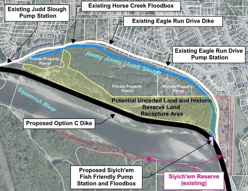
From Siyich’em Reserve to Fisherman’s Park, the original preferred option selected by District of Squamish and Squamish Nation Councils was to re-align the Squamish River dike as shown below in order to re-capture historic reserve land lost due to erosion by the Squamish River.
In the Eagle Viewing Area, the concept design entails raising the existing dike by up to 1.5 m additional height and expanding the footprint towards Government Road, without impacting the road. Depending on the available space between the existing dike and Government Road, the dike upgrading geometry may involve a grass slope with or without an adjacent berm, or a retaining wall.
Pre-Design Study
In 2021, the District and Squamish Nation initiated work on a Pre-Design Study in order to continue advancing the project and implement recommendations of the Dike Master Plan. The scope of work included hydraulic modeling, environmental and geotechnical assessment, engaging with regulatory agencies, and updating the concept design and cost estimates.
Based on technical assessments completed in the Pre-Design Study, substantial implementation issues were identified. It was confirmed that due to environmental impacts associated with re-aligning the dike closer to the Squamish River, the feasibility of re-aligning the dike is contingent on a very large habitat compensation to re-water Pilchuck Creek / Chicken Soup Slough in the upper Squamish Valley. Due to the technical and logistical challenges associated with this enhancement opportunity, the District and Squamish Nation have recognized that a decision in favour of pursuing the enhancement opportunity would not be reached on a timeline compatible with completing urgent dike upgrades.
In late 2024/early 2025, District and Squamish Nation Councils expressed support to re-visit previously short-listed options identified in the Dike Master Plan in tandem with pursuit of offsite opportunities to redress historical decisions and restore useable reserve lands.
Next Steps
Work is scheduled in 2025 to re-visit two previously short-listed options for dike upgrades on Siyich’em Reserve which includes:
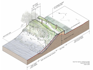
- Option A – Retaining Wall – This option would involve raising the existing dike and minimizing the need for additional space through the use of a vertical retaining wall on the land side of the dike.
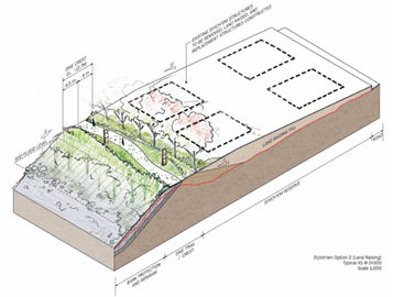
- Option B – Land Raising – This option would involve filling the land on Siyich’em Reserve to strengthen the dike and allow raising.
It is possible that the final preferred option may include a hybrid of the above options.
The concept design for upgrading the Squamish River dike through the Eagle Viewing Area is intended to remain the same, however, the design will be refined to minimize in-water work and associated environmental impacts.
Funding
All work undertaken to date on this project has been 100% funded through senior government grants.
Dike Master Plan: Study Area and Background Information
-
What is the Eagle Viewing Area / Siyích'em Reserve Dike Master Plan?
The development of the Dike Master Plan involved evaluating options for upgrading the dike protecting Brackendale, Siyich’em Reserve and Garibaldi Estates in accordance with the recently completed Squamish Integrated Flood Hazard Management Plan. It also considered non-flood protection challenges and opportunities for the area.
The project considered possible dike alignments and other flood protection options for the area to develop a plan which accommodates a number of considerations, including:
- Shared jurisdiction between the District and Squamish Nation;
- Infrastructure on, through, and next to the dike;
- Encroaching development;
- Private property challenges;
- Impinging river flows and debris impact;
- Sensitive environmental habitat areas; and
- Tourism and recreational use.
-
Where is the study area?
The Master Plan development originally focused on the area of the Squamish River dike between the northern end of Siyích'em I.R. No. 16 and the northern end of Kowtain I.R. No. 17. However, through the options development phase of the project (Fall 2019), the study area was expanded to the southern boundary of Aik’wucks I.R No. 15/Fisherman’s Park.
The study area and existing features are presented in the following figure:
Click image to view larger version.

-
Why is a dike upgrade needed in this area?
The Integrated Flood Hazard Management Plan found that the Squamish River dike in this area is deficient in the following ways:
- A history of seepage and “piping” issues;
- Piping occurs when the water pressure on the dike causes fine-grained material such as sand and silt to be pushed out through the dike foundation. Piping starts typically near the land-side slope toe of the dike and can be observed as sand boils or small mounds of fine-grained material found inside a seepage pond. As more material is pushed out, a cavity (i.e. pipe) forms from the land-side slope toe towards the water-side of the dike. This can lead to dike instability and breaching. Piping concerns can be avoided/mitigated through dike design and construction best practices
- Dike cross-section not meeting provincial design guidelines due to changing guidelines from when it was first built;
- Unknown subsurface conditions due to age of the dike;
- Inadequate dike height;
- Vegetation impacts to dike; and
- Uncertain seismic performance.
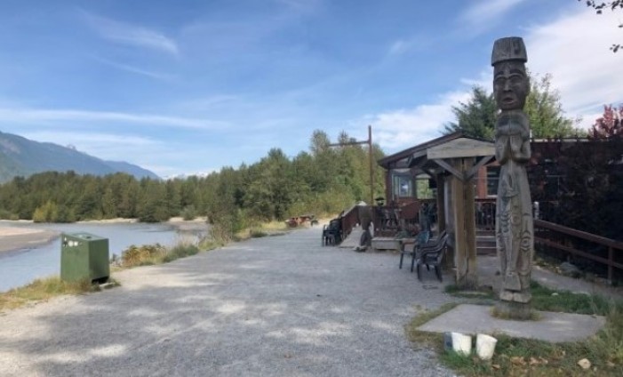
This section of the Squamish River Dike is particularly vulnerable as the river flows directly into the dike at the north end of the Eagle Viewing Area, and due to the deficiencies discussed above. Additionally, there are a number of considerations to take into account based on the varied uses of the area, and therefore an early planning process involving community input was/is necessary before detailed design and construction.

River level during October 2003 event near Eagle Viewing Area

Same location as previous during normal flow conditions.
- A history of seepage and “piping” issues;
-
When will the dike upgrades be built?
There is still significant remaining work to determine a preferred dike upgrade option , advance the design, secure grant funding and receive permits. There will be additional opportunities for public input as the project continues.
-
What is the project schedule and where are we now?
Eagle Viewing Area / Siyich’em Reserve dike planning has included the following work to date.
Date Range Work Undertaken 2014 - 2017 Integrated Flood Hazard Management Plan 2020/21 Eagle Viewing Area / Siyich’em Reserve Dike Master Plan 2021-2024 Siyich’em I.R 16 and Eagle Viewing Area Dike Pre-Design Study Planned 2025/26 Revisit short-listed options and select a new preferred dike upgrade option -
Community engagement
Community participation was and continues to be important to the success of the project.
In development of the Master Plan, community input was previously gathered through the following activities:
- Introductory online survey #1 (Fall 2019)
- Shortlisted options review meetings with Squamish Nation members, Siyich’em residents, Government Road land owners/businesses, and community/environmental groups (November 2019)
- Shortlisted options public open house (December 5, 2019)
- Correspondence with regulatory agencies (November/December 2019)
- Shortlisted options online survey #2 (December 2019)
- Public Presentations to District and Squamish Nation Councils (February 2020)
- Online Survey #3 (Summer 2020)
- Correspondence with stakeholder groups (Summer 2020)
- Review meeting with Squamish Nation members (Siyich’em Reserve families and residents (October 2020)
- Public Presentations to District and Squamish Nation Councils (November 2020)
There is still much work to be done. The timing of the upgrades will depend on confirmation of feasibility of the new alignment (i.e. ability to receive permits from regulatory agencies), completing necessary studies identified in the plan, securing grant funding and other District and Nation priorities.
Prior to construction, there will be additional opportunities for public input.
-
Additional Information and Contact Information
If you would like additional information, you may wish to review the final Dike Master Plan.
Alternatively, the following District staff may be contacted with questions:
David Roulston
Senior Manager of Infrastructure Planning
District of Squamish