Mamquam Ring Road Repairs and Upgrade

Background

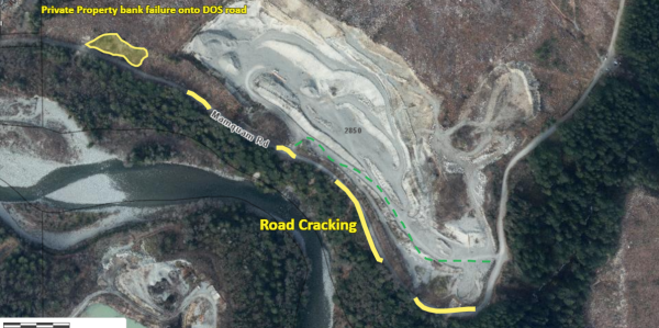
The atmospheric river event on November 13-15, 2021 contributed to significant damage along portions of the Mamquam Ring Road, located above the golf course and below the university zone. There were slope failures along the downhill side of the road, road cracking, erosion, and a significant landslide and slope instability from the uphill side of the road. The District immediately closed the road to the public as a result of the damage.

The yellow lines indicate the location of the erosion and road cracking along the Mamquam Ring Road; the yellow polygon on the north-west end indicates the location of the landslide and slope instability on the uphill side of the road (on private land).

Photo of Mamquam Road with highlighting indicating road cracking and private property bank failure onto the road.

After addressing the immediate issues, a remediation plan was developed to rehabilitate the general slope instability and road cracking. The scope of work included re-profiling the over-steepened slopes, shifting and rebuilding the road away from the bank where possible and building a retaining wall where not, as well as completing drainage improvements to collect and redirect water to suitable locations.

This work commenced in late 2022 and was substantially completed in Spring 2023. The work cost approximately $434K over two years.

The provincial organization Emergency Management BC supported the District with approximate $172K in funding.

There is a section of repair work on private property that is required before the road can be re-opened. The work entails stabilizing a 40m high and 45m wide bank which requires moving of a large amount of gravel from the area to remove the risk of further landslides. The landowner has not provided a schedule for completing the work but the District is working with them to complete it as soon as possible.

The road will be re-opened to industrial traffic only. Once the repairs are complete, the road will remain gated as it was before the atmospheric event in November 2021. The road will continue to be closed to the general public traffic as the road is only one lane in multiple areas due to previous road damage. Due to the narrowness of the road in these areas, only professional industrial drivers with truck radios that can communicate with each other will be permitted to use the road. The road can be used in both directions by these industrial vehicles.

The District manages the gates on either end of the road and companies must apply for gate keys in order to access the road.

Yes, once all the repairs are complete, cyclists and pedestrians will be permitted to use the road again.

Industrial traffic can apply for a gate key to use Mamquam Ring Road which will provide them with an alternate route to Highlands Way South.

In addition to industrial, cyclist, and pedestrian users, this section of Mamquam Ring Road is an alternate emergency access / egress to the university area.

The primary emergency route is the Boulevard but in the case of large influx of traffic or if the Boulevard was cut off, the Mamquam Ring Road could be used as an emergency route. District staff would direct the use and manage the traffic of the road in that scenario.


Post your comment

Comments

No one has commented on this page yet.

RSS feed for comments on this page | RSS feed for all comments