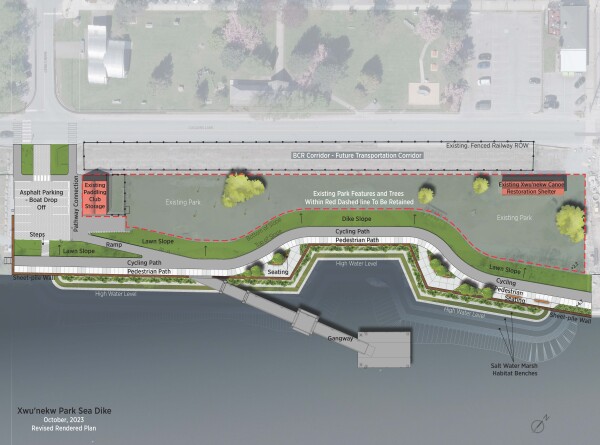
X̱wún̓eḵw Park Sea Dike
The X̱wún̓eḵw Park (pronounced Whoo-Nay-Oak) Sea Dike is an integral part of the ongoing dike upgrade program identified in the District’s Integrated Flood Hazard Management Plan (IFHMP). The District of Squamish has developed a detailed design and submitted permitting applications for the X̱wún̓eḵw Park Sea Dike, which will upgrade the shoreline to provide flood protection and increase climate resilience of Downtown Squamish. The park is located on the Mamquam Blind Channel and Loggers Lane between Victoria and Main Street.
Along with the new vertical sheet pile dike and waterfront walkway, the design includes an integrated habitat enhancement area for intertidal plantings. The project will also include the installation of a concrete pier that supports fixed gangways from the dike down to a floating dock on the Mamquam Blind Channel. This public water access will initially support the hand-launching of non-motorized watercraft (kayaks, surf skis, stand-up paddleboards and canoes etc). This first phase of work at X̱wún̓eḵw Park has aimed to maintain flexibility for future park/community use of the upland and the potential for additional marine infrastructure or uses that will be determined through long-term park planning and community engagement.
Project Timeline + Costs
In the fall of 2019, the District engaged a multi-disciplinary project team (civil/geotechnical engineers, landscape architects, environmental professionals and engagement specialists) to lead detailed design, engagement and project permitting. Following receipt of all provincial and federal approvals (August 2024), the District will be required to begin in-water construction (approximately a 6-month duration) during the least-risk fish window (August 16-Jan. 31).
The total cost of the project is $18 million (2024 cost plan). Cost increases from the original budget estimate of $11 million are due to increased habitat requirements for the Fisheries Act authorization and overall construction cost inflation. The District received a grant in the amount of $4,049,878 under the Investing in Canada Infrastructure Program – Rural and Northern Communities by the Government of Canada and the Province of British Columbia. The remaining costs are being funded by the District of Squamish through grants, borrowing and community amenity contributions.
Impacts
Impacts will be significant during construction and will include the closure of the park and Main Street parking area, and noise and traffic impacts due to use of cranes, pile drivers, excavators and trucks. The District will strive to mitigate noise and community impacts during construction. Alternative public water access during the dike construction period will be from the newly opened Sp'akw'us Feather Park at the Squamish Oceanfront (37000 Sp'akw’us Landing).
Updates
December 2025
The contractor will be completing essential habitat bench construction during upcoming low-tide windows which occur overnight. Night work will take place intermittently until January 30, for approximately 10 nights in total which is required to meet environmental and regulatory conditions.
The contractor will be using controls to minimize noise and light disruptions as much as possible during this time. We appreciate your patience while we undertake this critical work.
June 2025
The District has awarded the construction contract for the project to Jacob Bros Construction. Works are planned to begin in July, 2025 with completion expected in Summer 2026.
October 2024 Update
The District posted a Request for Construction Proposals on October 24, 2024, inviting qualified contractors to bid on the construction of the new sea dike. This process will enable the District to identify a preferred contractor for delivering the upgrades at X̱wún̓eḵw Park to provide an enhanced public space, upgraded water access, and improved flood protection.
August 2024 Update
On August 1, 2024 the District received approval from the Department of Fisheries and Oceans Canada to proceed with the X̱wún̓eḵw Park Sea Dike project. This milestone marks years of work to advance the design and permitting process since 2020, and brings the District one step closer to realizing a revitalized X̱wún̓eḵw Park. Next steps involve project planning for tendering and scheduling the project for construction.
November 2023 Update
The District has received permits under the Canadian Navigable Waters Act, Dike Maintenance Act and Heritage Conservation Act. The habitat compensation design has been modified to include expanded intertidal marsh benches in front of the sheet pile wall and continues to work with Fisheries and Oceans Canada to finalize the habitat compensation plan necessary for approval under the Fisheries Act. Subject to permitting, the District is aiming to begin construction during the upcoming least-risk fish window (August 15 to January 31).
November 2021 Update
Archaeological assessment work was conducted at X̱wún̓eḵw Park (November 18 -19) in relation to the sea dike development. A team of six people participated in the fieldwork which involved intermittent partial closures within the park without impacting the park’s access, parking or beach access.
The detailed sea dike, waterfront walkway and water access design phase is now complete and permitting applications under the Canadian Navigable Waters Act, Dike Maintenance Act, Fisheries Act and Heritage Conservation Act have been submitted. The District is currently completing an Archaeological Impact Assessment in advance of any site works to evaluate and manage for any potential archeological resources on the site. Construction timing is dependent upon approval of Provincial and Federal permits, and the District aims to initiate construction in early 2022.
May 26, 2021 - Canadian Navigable Waters Act Application
The District of Squamish submitted an application with the Minister of Transportation for the following work:
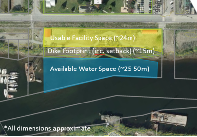
- Installation of a 200m long sheet pile sea dike following along the high water mark.
- Installation of a new gangway and dock to provide public access to the water.
- Installation of rip-rap berm as an environmental enhancement measure along the base of the sheet pile wall.
Read the Notice of Application: Canadian Navigable Waters Act.
July 2020 Update
On July 21, 2020, Council reviewed the preliminary dike concepts and endorsed Option 2 (see below for a detailed description). Next steps involve detailed design and permitting phases of the project.
View the July 21 Staff Report and Community Engagement Results.
June 2020 Dike Concepts + Public Survey:
Following geotechnical site investigations conducted in February, initial preliminary concepts were developed based on technical dike design, as well as community water access criteria. Two initial design concepts for the sea wall and plans for interim park improvements at X̱wún̓eḵw Park were presented for community input through an online public survey that closed July 14.
Dike concepts and options
Option 1: A straighter linear alignment for the sheet pile wall that links to and extends south from Victoria Street to Main Street. This option requires additional fill and associated habitat compensation but maintains more upland usable park space. View Option 1
Option 2: A ‘notched’ or inset sea wall that preserves the historic indent along the shoreline that was used for log dumping during the mid-1900s when the site was used by PGE Railway. This option requires less fill and associated habitat compensation than Option 1 but reduces the usable upland area. View Option 2
The sheet pile wall alignment under both options follows the average High Water Mark (HWM) to reduce the amount of infill of the channel, while providing useable upland area for future use. The overall alignment was reviewed and supported by Council in November 2019. For more information, please refer to the November 12, 2019 report to Council.
The final design will integrate habitat enhancement and restoration features to increase ecological complexity and habitat value in the marine environment; constructed habitat structures under consideration include textured panels, habitat skirts, benches and steps, and niche habitats (reef balls, voids, mounds).
On the upland, both options include an extension of the waterfront pathway that is planned to continue along the channel for pedestrians and cyclists. The dike elevation (4.7m) transitions down into the park area, where existing park amenities, such as the paddle storage facility and the X̱wún̓eḵw Canoe Restoration Shelter, are preserved for the near term along with public parking and drop-off at Main Street (South end). Community water access for self-propelled watercraft is proposed to allow for water access through a series of platforms, gangways and a floating dock. Flexibility for future potential upland and waterfront uses includes municipal and community uses. At this time no decision has been made as to future long-term use of this site.
Project background and details
The site of X̱wún̓eḵw Park and the surrounding area has a rich history dating back long before western settlement when Squamish Nation used the west side of the Mamquam Blind Channel for beaching large ocean-going canoes. The name ‘X̱wún̓eḵw’ means ‘where large canoes are beached’ in Squamish language. The land is presently utilized for a variety of uses including the X̱wún̓eḵw Canoe Shelter used for restoration of canoes by Squamish Nation, Squamish Paddling Club Storage and open space uses such as slack lines.
X̱wún̓eḵw Park is surrounded by a variety of ongoing and future land development. These include the Sirocco development which will include a ramp and dock from the dike down to the water near the Victoria Street road end, and the Waterfront Landing pedestrian bridge which will ultimately terminate on the dike at Victoria Street. Potential for future uses of the land and water include community facilities, park use, water/transportation access and on-water boat storage.
The District's Integrated Flood Hazard Management Plan identifies the construction of a new sea dike as a priority in order to meet Provincial standards for protecting the community from coastal flood hazards.
The proposed X̱wún̓eḵw Park Sea Dike will utilize a steel sheet pile with a vertical face on the water side of the dike to avoid encroaching on the existing canoe shelter and paddling storage. The dike top will include a cycling and pedestrian path and will include street furniture, landscaping and lighting. The pathways will connect to the existing Sirocco waterfront pathway and future Waterfront Landing pedestrian bridge at the Victoria Street end.
There will be a water access ramp and floating dock leading from the crest of the dike down to the water that has been designed to maximize accessibility during the lowest tides. An extensive series of intertidal marsh planting benches are proposed in front of the sheet pile wall to compensate for habitat impacts caused by the construction of the dike.
Design Overview
- Provides flexibility for future land and water community uses.
- Creates/maintains non-motorized water access with gangway and public dock.
- Improves marine habitat through the use of a 'naturalized habitat skirt'.
- Adds to continued waterfront trail experience along the Mamquam Blind Channel.
Public Engagement
For the dike and water access design in this initial phase, the District has continued to solicit feedback from marine and park recreation interests, environment stakeholders, the general public, local tourism and business sectors and governments including the Squamish Nation, Province of BC and Federal agencies. Guided by the IAP2 spectrum of engagement, the process has sought to inform, consult, and involve stakeholders at various stages.
Community engagement activities to date have included user group outreach and a virtual focus group workshop, followed by a Community Survey to solicit comment on technical design concept(s), water access, and integration of parks and other uses. Due to the emergency COVID-19 response, in-person information meetings were replaced with online updates and resources via the District’s main communication channels to allow for alternate participation and dialogue. Please see the Comment Form and Project Contacts at the bottom of this page.
Staff Contacts
Reid Plasterer, Project Manager rplasterer@squamish.ca, 604-848-9811
Sarah McJannet, Senior Planner smcjannet@squamish.ca 604-848-9366