Marine Information

Marine Updates

The final Squamish Marine Access Review (SMAR) document, incorporating extensive inputs from the community, was endorsed by District of Squamish Council on May 7, 2024. The purpose of the Downtown Marine Access Review was to assess community ocean access needs, coordinate marine access areas and infrastructure, and improve ocean access for all marine users. Working with the community, the project supports ongoing planning for an inclusive, accessible, safe, healthy, vibrant and working waterfront for all.

View the SMAR Project Page including engagement materials and archived links

A status update respecting the completion of the Mamquam Blind Channel (MBC) Maintenance and Funding Strategy was presented to Council Committee of the Whole on Tuesday May 7, 2024.

For more information see the MBC Maintenance and Dredging Strategy project page.

Marine Access Reference Maps

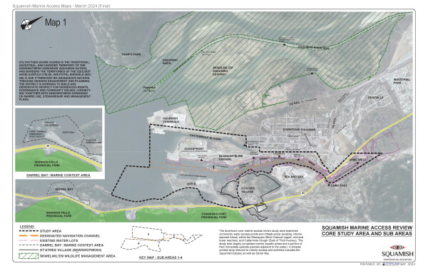
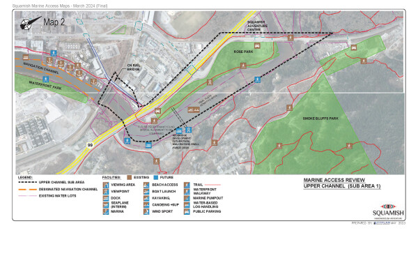
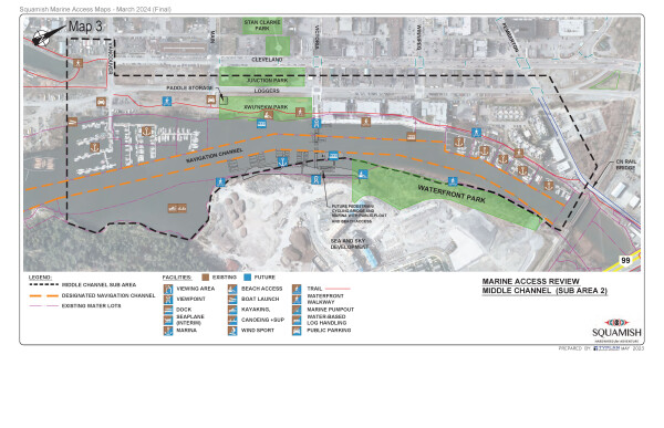
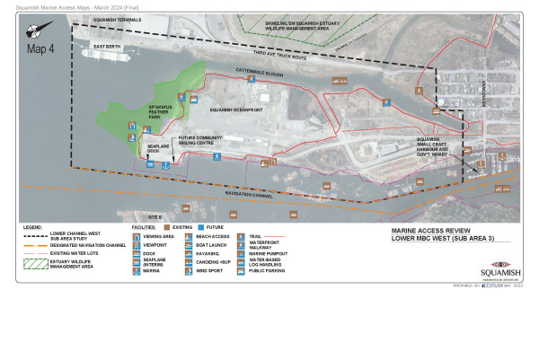
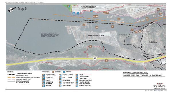
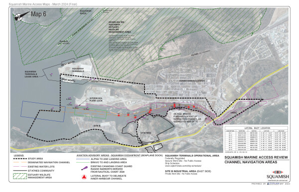
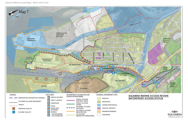
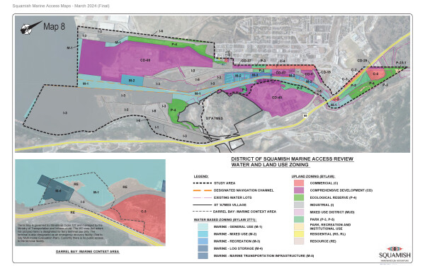
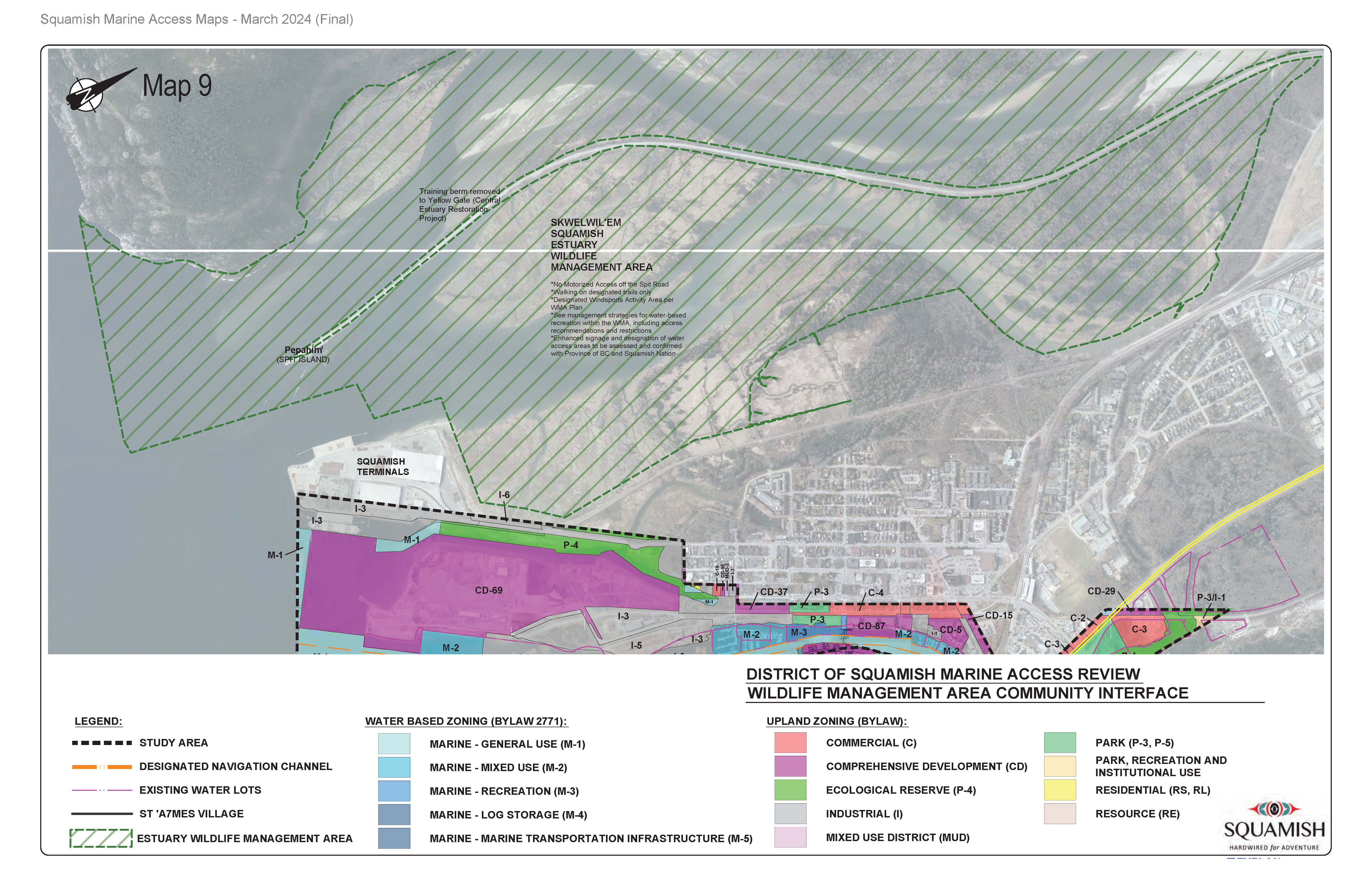
The District has prepared Downtown Marine Access Maps that present a consolidated snapshot highlighting downtown lands and waters, managed areas and water and upland uses, key access points along the foreshore, and waterfront facilities and infrastructure (both existing and future planned). They offer a point of reference and are intended for information purposes to help guide and coordinate tactical plans for improved connectivity, accessibility, marine safety, protection and stewardship of marine areas in Squamish.

The information contained in these maps is for reference purposes only; inconsistencies and irregularities may occur. More accurate information may exist in other records. For additional information please see Squamish Webmaps.

Contact the Community Development Department with questions: [email protected].

Core study area map

Click map to open pdf in new tab.

Marine access in upper channel outlined in black.

Click map to open pdf in new tab.

Map with middle channel marine access highlighted.

Click map to open pdf in new tab.

Map with lower Mamquam Blind Channel access highlighted.

Click map to open pdf in new tab.

Map outlining lower mamquam blind channel marine access

Click map to open pdf version in new tab.

Map highlighting channel navigation areas.

Map showing waterfront access status and general ownership type.

Click map to open pdf version in new tab.

Map highlighting water and land use zoning.

Click map to open pdf version in new tab.

Map highlighting wildlife management area community interface.

Click map to open pdf version in new tab.

Learn more about the Skwelwil’em Squamish Estuary Wildlife Management Plan, including objectives and management strategies for maintaining and restoring fish, wildlife and their supporting habitat within the WMA.


Marine Resources

UNESCO Biosphere Region

Atl'ka7stem/Howe Sound

Marine debris found within Átl'ḵa7tsem/Howe Sound

Prevent the spread of aquatic invasive species

Marine Navigation - Important Information

Boating Safety

Marine Weather Conditions and Forecasts - Howe Sound

Local Marine Traffic

Marine Mammal Regulations - Keep your distance - It's the Law

Marine Mammal Regulations apply year-round in Canadian Pacific waters. Stay 400 m away and do not position a vessel in the path of killer whales in all southern B.C. coastal waters. For more information: Map overview of 2024 management measures to support Southern Resident killer whale recovery | Pacific Region | Fisheries and Oceans Canada (dfo-mpo.gc.ca)

Anchoring and Moorage

No anchoring is allowed within the designated navigation channel in the Mamquam Blind Channel nor in public or private water lots outside of established marina facilities. The navigable channel is marked by green and red buoys from the Pemberton Rail Bridge to the southern reach of the channel. Vessels must not impede navigation in the channel. Navigation safety is enforced by Transport Canada. The lateral buoy markers are maintained by the District of Squamish.

View Marine Reference Map 6 - Regulated and Managed Areas

In 2022 the District of Squamish adopted new marine zoning regulations to enhance the coordination, shared use, stewardship and protection of marine coastal areas within the District of Squamish. Five new marine-specific zones (M1-M5) with associated regulations govern permitted uses below the natural boundary of the sea (High Water Mark, or HWM). For more information visit www.squamish.ca/marine-zoning

View Marine Reference Map 8 Water and Land Use Zoning

Marine Zoning Anchorage Restriction* Except in a permitted marina or moorage facility, the anchoring or moorage of a vessel for a continuous period exceeding 48 hours, and the anchoring or moorage of a vessel for more than a total of 72 hours within any 30-day period, are prohibited in all marine zones.

Marina Facilities - Mamquam Blind Channel

Six (6) marinas currently provide approximately 244 moorage spaces for locals and limited visitor moorage (seasonal). For more information please contact the marinas directly:

  • Squamish Harbour Authority - 37778 Loggers Lane
    • ‘Non-core fishing’ harbour and 1 hectare (ha) waterlot managed by the Squamish Harbour Authority (SHA) under a lease administered by Fisheries and Oceans Canada.
    • Certified Green Marine facility with free public marine pump out facility available 24/7
  • Squamish Yacht Club - 37778 Loggers Lane
  • Squamish Marina - 38124 Loggers Lane
  • Blue Heron Marina - 1476 Pemberton Ave
  • Sea to Sky Marina -1468 Pemberton Ave
  • Upper Newport Marina - 1498 Pemberton Ave

Marine Contacts

District of Squamish - Marine Area Planning

Province of BC - Report All Poachers and Polluters (RAPP)

  • Report violations of fisheries, wildlife, or environmental protection laws via the online form or contact the Conservation Officer Service 24-hour hotline: 1-877-952-7277
  • Salmon-related violations should be reported to Fisheries and Oceans Canada (DFO): 1-800-465-4336

Fisheries and Oceans Canada (DFO)

  • Report any violations or incidents involving marine mammals (that you observed or were involved in) or salmon-related violations to Fisheries and Oceans Canada’s 24/7 Observe, Record, Report line: 1-800-465-4336
  • Email: [email protected]

Oceans Protection Plan

Wrecked, Abandoned or Hazardous Vessels Contact Chart

  • Canadian Coast Guard - Western Region: 1-800-889-8852
  • Transport Canada Navigation Protection Program - Pacific (BC): 604-775-8867