Integrated Flood Hazard Management Plan
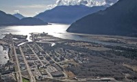
Following a three-year process including extensive technical work and community engagement, the Integrated Flood Hazard Management Plan (IFHMP) was adopted by District of Squamish Council on October 17, 2017. The plan weaves together elements of land use planning, structural protection, river management, public education and emergency planning and will be utilized for capital and community planning for the next five to ten years.
The final IFHMP provides flood protection improvements including a comprehensive plan to:
- Address all known deficiencies in the existing dike network,
- upgrade the existing sea dike to protect against both current and future anticipated sea levels and
- adopt a higher standard of protection for the Squamish and Mamquam River south dikes in light of the significant development they protect.
The plan also includes recommendations for new Official Community Plan Hazard Policy, a Development Permit Area, and a new Floodplain Bylaw to ensure that new development is planned and constructed to ensure Squamish’s resiliency to flooding.
View the Report
Details can be found in the Final IFHMP Report. (large file)
View the IFHMP Map.
Is Squamish prepared for a flood event? Visit the Emergency Program page to learn about Squamish Emergency Preparedness.
How was the plan developed? Visit the IFHMP project page for details.
Resources:
District Plans
- Background Report (large file)
- Coastal Flood Risk Mitigation Options (large file)
- River Flood Risk Mitigation Options (large file)
- Integrated Flood Hazard Management Plan (large file)
- Squamish Flood Hazard Management Plan, Klohn Leonoff (1994)
- West Mamquam Blind Channel Flood Hazard Management
District Policies
- Official Community Plan
- Floodplain Management Bylaw
- Terms of Reference for Natural Hazard and/or Risk Assessments
Provincial Policy