Atmospheric River 2021
High Streamflow Advisory issued for Howe Sound and Sea-to-Sky
The forecasted significant rainfall event has prompted a High Streamflow Advisory* by the River Forecast Centre.
A significant atmospheric river is expected to impact southern coastal regions of British Columbia starting today. This is forecast to bring heavy rainfall throughout Saturday night and Sunday, and ease on Monday. Environment and Climate Change Canada have rainfall warnings in place with rainfall around Howe Sound to be upwards of 150mm total rainfall amounts expected by Monday.
Temperatures are expected to rise throughout the atmospheric river, with freezing levels pushing 2000 m elevation on Sunday before cooling on Monday. Additional snowmelt of recent snow accumulations at mid-elevations (1000-1500m) is expected to add to river runoff.
Rivers are expected to rise rapidly throughout Sunday in response to rainfall, and ease on Monday as the heaviest rainfall passes. Current modelling is indicating the potential for flows in the 2-year to 5-year range.
*A High Streamflow Advisory means that river levels are rising or expected to rise rapidly, but that no major flooding is expected. Minor flooding in low-lying areas is possible.
A Flood Watch means that river levels are rising and will approach or may exceed bankfull. Flooding of areas adjacent to affected rivers may occur.
A Flood Warning means that river levels have exceeded bankfull or will exceed bankfull imminently, and that flooding of areas adjacent to the rivers affected will result.
Rainfall Warning up to 150 mm Sunday to Monday
Environment Canada has issued a Rainfall Warning for Howe Sound.
A Snowfall Warning is also in effect for Sea to Sky - Squamish to Whistler for Saturday night, with accumulation of up to 15 cm ahead of the rain event.
A significant atmospheric river event will bring copious amounts of rain and near record temperatures to the B.C. south coast beginning late this afternoon. As the warm front approaches, steady rain will develop late this afternoon.
Rainfall up to 150 mm for Howe Sound is expected for Sunday and Monday. Warm temperatures will accompany the rain.
Rising freezing levels with melting snow giving rise to increased river flows and localised flooding.
The rain will be heaviest Sunday afternoon and Sunday night ahead of the cold front. The heavy rain will ease on Monday as the cold front pushes the precipitation out of the region.
This could result in possible washouts, debris flow and pooling water as rising freezing levels will also melt snow at higher elevations. Local river levels will rise and river flows will increase as a result of the heavy rain.
Near record temperatures will also accompany this system.
Heavy downpours can cause flash floods and water pooling on roads. Localized flooding in low-lying areas is possible. Watch for possible washouts near rivers, creeks and culverts.
Please continue to monitor alerts and forecasts issued by Environment Canada. To report severe weather, send an email to [email protected] or tweet reports using #BCStorm.
Flood Watch issued for Howe Sound and Sea to Sky
http://bcrfc.env.gov.bc.ca/warnings/advisories/FWT_2021_10_15_1530_SC_upg.pdf
November 15, 2021
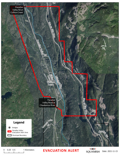
Evacuation Alert issued for Paradise Valley properties in areas upstream of the Bailey Bridge
BC Hydro Spill Notice and Flood Alert in effect
An Evacuation Alert has been issued by the District of Squamish Emergency Operations Centre for Paradise Valley properties in the areas upstream of the Bailey Bridge.
Because of the potential danger arising from rising water levels and flooding due to heavy rainfall and the BC Hydro Spill Notice, the District of Squamish has issued an Evacuation Alert for the following area:
- Areas upstream of the Bailey Bridge as shown below.
- An information checkpoint for affected residents has been established at the Bailey Bridge;
- It is advised that residents avoid unnecessary travel to the Paradise Valley Road area.
An Evacuation Alert has been issued to prepare affected residents to evacuate their premises or property should it be found necessary.
WHAT YOU SHOULD DO WHEN AN ALERT IS IN EFFECT:
Upon notification of an ALERT, you should be prepared by:
- Locating all family members;
- Moving pets and livestock to a safe area;
- Preparing a bag, box, or suitcase with important items such as passports, birth and marriage certificates, insurance documents, and prescription medicine;
- Packing emergency supplies including a radio, cellphone charger, water and snacks, emergency blanket, first aid kit, seasonal clothing, and cash.
BC Hydro Spill Notice and Flood Alert in effect
The District of Squamish received a Spill Notice informing of a planned spill release through the spill gates at the BC Hydro Cheakamus Dam. BC Hydro is required to issue a Spill Notice when discharges are greater than 170 cubic metres per second.
Rapid increases in water levels within the next 24 hours are possible. There is the potential for top of river bank flow (bankfull conditions).
Inflows to Daisy Reservoir are high and the Reservoir is forecasted to exceed 376.5 metres this evening. Spill from Daisy Dam will be increased to ~300 cubic metres per second and there is potential to exceed 450 cubic metres per second discharge at Brackendale if natural inflows do not subside. Inflows are expected to start receding this evening and into tomorrow.
Residents and visitors are reminded to be cautious around the edges of the Cheakamus River during
these increased flow periods, and continue to be mindful of water safety.
A Squamish Alert was issued to affected residents and additional evacuation route details will be provided to affected residents if an evacuation becomes necessary. To subscribe to the free emergency notification service visit squamish.ca/alert.
November 15, 2021
Evacuation Alert Rescinded for Paradise Valley
Previously declared BC Hydro Flood Alert downstream of Cheakamus Dam has also been rescinded.
River Forecast Centre has also rescinded Flood Watch for Howe Sound and Sea to Sky
The District of Squamish Emergency Operations Centre has RESCINDED the Evacuation Alert for Paradise Valley properties in the areas upstream of the Bailey Bridge.
The current conditions have improved to the degree that the current Evacuation Alert is no longer required for those in the Paradise Valley.
BC Hydro Spill Notice remains in effect
The BC Hydro Spill Notice of November 15 is still in effect informing of a planned spill release through the spill gates at the BC Hydro Cheakamus Dam. This is expected to continue over the coming days to reduce the volume in the Daisy Reservoir.
BC Hydro has provided the following information: Spill from the Dam is 193 cubic meters per second and will be held until a rampdown plan is developed for Wednesday. Discharge at the Brackendale measuring station (on the Cheakamus River at Brackendale) is 276 cubic meters per second and is expected to decrease as inflows recede.
It is recommended to continue to keep a distance from unstable river banks and stay off the rivers and water ways for the next 24 hours.
Further related issues can be reported to the District of Squamish at 604.815.4040.
November 16, 2021
High Streamflow Advisory in effect
The River Forecast Centre is issuing a High Streamflow Advisory for Howe Sound and the Sea to Sky including areas around Squamish, Whistler and Pemberton
A prolonged period of active weather is expected throughout coastal B.C. over the coming week as several atmospheric rivers pass over the region. The first of these is expected to make landfall later on Wednesday, starting on the North Coast and Central Coast, and sliding southward into Thursday. This storm is expected to bring heavy rainfall, with rainfall totals in the 40-70 mm range over the Fraser Valley and 50-80 mm over the North Shore Mountains, and higher amounts possible over higher terrain.
Subsequent atmospheric river events are forecast on the weekend, starting up again later on Saturday. Additional storms are expected early next week. There is still considerable uncertainty over the locations and severity rainfall of the weekend and next week storm cycles, however the pattern of extremely active weather and heavy rainfall is expected throughout the advisory region.
Rivers are expected to see rises on Thursday in response to rainfall, with the potential for highest flows (2-year to 5-year) expected around the Sunshine Coast, Howe Sound and North Shore corridor. Rivers in the Fraser Valley are expected to see rises, though currently these are expected to be more typical in magnitude for fall storms, however these may be more problematic to flood response and recovery efforts and damaged infrastructure in the region.
Persistent periods of high flows are expected over the weekend and into next week. Additional information will be provided later in the week (Thursday and Friday) as weather and river forecasts see decreased uncertainty.
The public is advised to stay clear of the fast-flowing rivers and potentially unstable riverbanks during the high-streamflow period.
The River Forecast Centre continues to monitor the conditions and will provide updates as conditions warrant.
A High Streamflow Advisory means that river levels are rising or expected to rise rapidly, but that no major flooding is expected. Minor flooding in low-lying areas is possible.
For the latest advisories and warnings visit the River Forecast Centre.
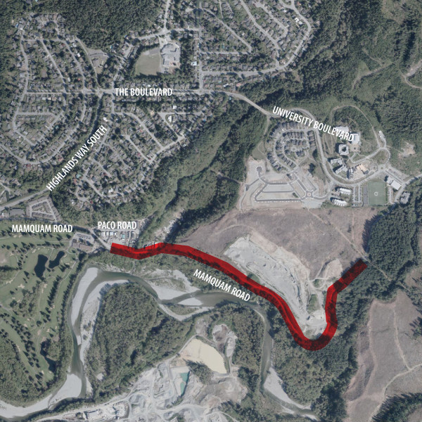
Geotechnical work underway to assess gravel portion of Mamquam Road
Area closed due to significant safety risk
The gravel portion of Mamquam Road (east of Paco Road below Quest University) remains closed due to fractures along a 400-metre section of the road as a result of last week’s atmospheric river event. A substantial landslide near the bottom of the road has blocked access. District of Squamish engineering staff have retained a local geotechnical engineer to review the cause of the failure and assess slope stability and potential remediation options. Barricades and prohibitive Do Not Enter signs have been installed to restrict public access, including by foot or bike.
“The public must stay off the road or out of any of the areas below the road while the geotechnical assessment is underway, as any slope failure poses an extreme risk to public safety,” says District of Squamish Director of Engineering Chris Wyckham. “We are closely monitoring the situation and will determine the appropriate next steps based on the geotechnical assessment.”
Tension cracks first appeared on the gravel portion of Mamquam Road, also known as the Mamquam-Ring Creek Road, on November 16 as a result of heavy rainfall.
The District will continue to provide further updates and next steps as work progresses.
Flood Watch in effect for Squamish
The River Forecast Centre has upgraded to a Flood Watch for the South Coast and Sea to Sky including areas around Squamish, Whistler and Pemberton, Sunshine Coast, Howe Sound and the North Shore Mountains.
A Flood Watch means that river levels are rising and will approach or may exceed bankfull.
Details:
The first of a series of storms has arrived on the South Coast. The storm is bringing heavy
rainfall, with rainfall totals forecast to range between 40‐70mm over the Fraser Valley and 50‐
80mm over the North Shore Mountains and Howe Sound, with higher amounts possible over
higher terrain.
A subsequent atmospheric river event is forecast for the weekend with precipitation arriving
mid‐day on Saturday. Rainfall totals are expected to be higher for the weekend event.
Additionally, temperatures will be warmer resulting in higher freezing levels. There is a greater
risk for a rain‐on‐snow event to melt much of the current snowpack, adding additional water
into rivers and creeks.
A third atmospheric river is forecast to reach British Columbia next Tuesday/Wednesday (November 30 to December 1). It is still too far into the future to provide exact details regarding the impacts and severity of this third storm.
Rivers are expected to see rises on Thursday in response to the first rainfall event, with the
potential for highest flows (2‐year to 5‐year) expected around the Sunshine Coast, Howe Sound
and North Shore corridor. Rivers in the Fraser Valley are expected to see rises, though currently
these are expected to be more typical in magnitude for fall storms, however these may be more
problematic to flood response and recovery efforts and damaged infrastructure in the region.
The second system arriving over the weekend will likely be more problematic. It is currently
forecast to have higher rainfall totals, warmer conditions resulting in additional snowmelt and
will occur immediately after the current storm system. There is potential for flows to reach 10‐
year to 50‐year levels (or higher)– likely occurring Sunday or Monday.
The public is advised to stay clear of the fast‐flowing rivers and potentially unstable riverbanks
during the high‐streamflow period.
The River Forecast Centre continues to monitor the conditions and will provide updates as
conditions warrant.
Stay tuned to the River Forecast Centre for updates.
Special Weather Statement: Heavy rain expected Tuesday and Wednesday
Issued at 2021-11-29 12:52 UTC by Environment Canada:
Special weather statement issued for:
Howe Sound, B.C. (082500)
Current details:
A prolonged period of heavy rain Tuesday through Wednesday.
Total rainfall: 50 to 100 mm.
Locations: Metro Vancouver, Fraser Valley, Howe Sound, Whistler, Sunshine Coast.
Timespan: Rain begins over the British Columbia south coast early on Tuesday morning. Rain becomes heavy at times over Metro Vancouver, Howe Sound, Whistler, and the Sunshine Coast on Tuesday morning then spreads to Fraser Valley on Tuesday night. Heavy rain will persist through Wednesday.
Other risks: Strong southeasterly winds with gusts up to 60 km/h near the Strait of Georgia will also accompany the storm.
Remarks: The third atmospheric river in just under a week will once again give rain heavy at times over the British Columbia south coast.
Heavy downpours can cause water pooling on roads. Localized flooding in low-lying areas is possible. Rising freezing levels and snowmelt may contribute to increased runoff.
Please continue to monitor alerts and forecasts issued by Environment Canada. To report severe weather, send an email to [email protected] or tweet reports using #BCStorm.
More details on the alert are available here.
Post your comment
Comments
No one has commented on this page yet.
RSS feed for comments on this page | RSS feed for all comments